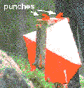
As for the worldwide sport with mental and physical challenge, the rules of orienteering are as follows: First of all, the participants should use a map which is provided by the organiser and find out every pre-set Control Point. At the same time, the participants should bring a provided Control Card in the course of event. When they reach a control point, they will find a Marker, a flag in orange and white colour,
 and a Punch under it. The participants can use the punch to make a record on their control card and the punch pattern can prove that they have already visited this point. After they have finished the course, they must return the control card to the organiser. The organiser will calculate their time and check the punch patterns are correct or not.
The winner will be the one who spend the shortest time and find out all required control points subsequently.
What equipment should I need?
Somebody may think orienteering is a 'harsh'
sport and last for days, climbing up high mountains and..., so you need to
carry food, tent, sleeping bag and other accessories with you in the
competition.In fact, you may just need 1
to 2 hours to complete an orienteering course. Therefore, you just need a
compass and a whistle (use in emergency only!) with you during the competition.
And the map and control card are provided by the organiser.
Of course, you
should wear appropriate clothes to protect yourself. Generally speaking, you
should wear trousers to protect your legs, and a pair of sport shoes to avoid
slipping on sandy ground.
You see,
orienteering is really a 'cheap' sport, you may spend less than HK$100 to buy
few equipment, and then you can enjoy the fun of orienteering!
Orienteering Map
Orienteering map, is the most important component of orienteering. Participants will solely use the information provided by the map to find out the control points, therefore, detail and accurate maps are essential.orienteering.
 In this sense, orienteering maps are quite different with maps we used in hiking or mountaineering in the following aspects:
- More detail than topography maps, small features such as gravels, boulders, indistinct paths, seasonal streams may shown on the map.
- Vegetation, i.e. the runnability of the area, are shown on the orienteering maps as participants may require cross-country.
- Relatively larger scale and smaller contour interval. In Hong Kong, mostly orienteering maps are in scale 1:10000 and 5m contour interval.
- Few 'words' , such as places' name, value of contour line are not shown on the orienteering maps.

Please refer to other orienteering maps and literature for more details.
The article was contributed by W.K.Choi, a domestic orienteer. All copyright are reserved.